May 31, 2009

Pamplin Historical Park's Main Entrance


There are three places at the Petersburg Battlefield that I would classify as don't-miss attractions. All require some walking but the trails are easy and well-maintained.
  • National Park Visitors Center and the trail out to where you can see "the Dictator"
  • The Crater
  • Pamplin Historical Park
We had almost two hours at Pamplin Historical Park and it wasn't enough to see all the highlights. If you can, allow four hours or more and wear comfortable walking shoes. You can enter through the Museum of the Civil War Soldier. Youngsters will love the "multi-sensory battlefield simulation" (unless they can't stand the noise).

Pamplin Park reminded me of Jamestown Settlement... so much reconstructed history that one gets a bit overloaded, but very well-done and entertaining.

Before you go, check on Admission Rates and Hours.

Walking in Pamplin Park


On the day our group toured Pamplin Historical Park, rain was forecast but it held off long enough for us to walk through the reconstructed military camp. This is a great place to get an idea of how Civil War era military structures looked.

The park includes actual Confederate earthworks and the breakthrough site where on April 2, 1865 "troops of Gen. Ulysses S. Grant’s Army of the Potomac broke through Lee’s defensive line, ending the nine-month campaign of Petersburg."

Battlefield Center, Pamplin Park

When our class visited Pamplin Park eleven years ago, the only building that was open to the public was the Battlefield Center. The picture to the left is one that I took then.

There was a museum inside, not yet complete but promising enough that I made a mental note to return in a few years and see the rest. Well, Petersburg was a 3-hour drive from home so I never made it there. Finally our class repeated the trip this spring so I got to visit the park again and was even able to share it with Frank.

Pamplin Park has 422 acres so we didn't get to see it all. I would like to return again to see Tudor Hall and the other historic buildings.

Below is a photo I took this trip of the Battlefield Center from the front, which features a facade that evokes "the zig-zagging Confederate earthworks located a short distance away."

Welcome Sign

Frank took this one at Pamplin Historical Park. They had posted this sign welcoming our group.

May 30, 2009

Sculpture at Pamplin Historical Park

Outside the National Museum of the Civil War Soldier,
Pamplin Park, Petersburg, VA

Purple and White Iris


Last year we purchased a mail-order collection of irises. Several have bloomed and they look spectacular.

Left: I added a dry-brush filter in Photoshop to this one.

May 28, 2009

Betty's Parasol

Betty carried her own shade at Petersburg. It was a hot and sunny day.

Rest When You Get a Chance


Sometimes our field trips are tiring, especially when the weather is hot. On our first day at the Petersburg Battlefield, group members started showing signs of fatigue around mid-afternoon. After all, most had been up before dawn and on the road around 7 AM in order to reach Richmond by 10:30.

Although our professor still looked energetic, many of us found a spot to sit down while he lectured, or at least found something to lean on.

(The artillery piece shown here is "the Dictator," or to be precise, the reproduction of it at Petersburg Battlefield.)


May 27, 2009

Interpreting Fort Conahey

Fort Conahey was the most elaborate Union fort built near Petersburg. The sign quotes a colonel's commentary:
"This fort has cost more labour than any other, has afforded an admirable lesson in engineering, and is one of the sights to show to strangers. Further than this I doubt the value of its elaborateness.”
- Col. Charles Wainwright, USA November 20, 1864
See a close-up of the Ft. Conahey sign and it's complete text at HMDB.org.

Acres of Irises

On Monday, we ignored the weather forecast of probable rainstorms and drove to Berkeley Springs to see the Exline Iris Garden. They have almost 1500 varieties of irises and I was curious to see them, plus I felt Frank would enjoy it because he remembers how his mother loved irises.

The garden is near the intersection of Potomac Road and Silver Road, not far from Route 9 east of Berkeley Springs, WV.

A reporter from a Martinsburg paper was there and quotes us in this
article about the Exline's garden. By the way, the rain held off until late that afternoon so it did not spoil our outing.

May 26, 2009

Seeing the Crater, Petersburg

signExcerpt from the sign "Prelude to the Crater:"
"The predawn darkness of July 30, 1864, shrouded intense Union preparations on this ridge. Thousands of troops filed quietly into the ravine and trenches in front. More than 160 cannon crowded the earthworks to your right and left. Maj. Gen. Ambrose E. Burnside, commander of the attacking force, took his place in the 14-gun battery (Fort Morton) behind you. By 3:30 a.m. all was ready. Only one detail remained: the explosion of the mine."
group at crater exhibit
wood lined tunnel When I toured Petersburg Battlefield with Dr. Poland's class in 1998, I was suffering from the heat. As temperatures approached 100 degrees F., my face showed my discomfort. Concerned classmates brought me wet towels and convinced me to spend some time resting instead of hiking out to the crater. So I didn't get to see it, although I did make it through the rest of the day without getting heat stroke, which I suppose had been a possibility.

This time the weather was not quite as steamy, and I sat out one of the other walking tours just to be sure that I'd be able to see the crater. I did get to see it and took these photos.

One thing I did not see until I looked at the last photo was the image of a soldier deep inside the shaft. (Can't see him? Click on the picture to enlarge it.)

Park Service Page: Battle of the Crater

May 25, 2009

A View from City Point

City Point, Virginia


At the time that U.S. Grant made his headquarters at City Point, the port here stretched 1.5 miles along the shore.

May 24, 2009

Class Picture, History 298


Here we see our Advanced Civil War class standing in front of Appomattox Courthouse. The building is now a visitors center run by the National Park Service.

I am in the second row. Click on a photo if you want to see it larger.

This is probably the last time Dr. Poland will conduct these trips in a 3-day format. He and his wife drive the entire route a few weeks ahead of the field trip, so the amount of time (and miles) they put into planning is incredible. Plus the very busy field trips are tiring, although the professor has better stamina than many of the students. (I cannot keep up with him!)

I hope he will continue to offer at least a single-day field trip in future years because the trips have been a highlight of each year for a long time. I started taking his classes in 1990, and have completed the entire series twice (following the Civil War chronologically). Two of the students in this photo have taken the class even longer (John B. and Arch). And Lachwan started the same year that I did.

See also our 2006 Class Picture.

May 23, 2009

Fort Harrison, Richmond

teaching outdoors

Dr. Poland Explains the Battle of Fort Harrison

The earthworks here are well-preserved.

The sign depicts a map of the fort and says:
fort harrison
Fort Harrison Trail
Both Federals and Confederates occupied this fort. Originally these earthworks were part of the 1862 Richmond line of defense.

When Federal troops overran the fort in 1864, they built more than half the earthworks you will see on the tour, and defended them till the end of the war.

May 22, 2009

Strolling

At Petersburg National Cemetery, Virginia

Tour: The Petersburg Campaign 1864-65

Saturday, May 16, 2009: Day 1 of an Overnight Trip
Civil War Field Trips, NVCC

This is the itinerary we followed on Saturday to study the battles around Richmond and Petersburg. Dr. Poland had previewed all the sites and placed them on a hand-drawn map.
  1. Fort Harrison and Fort Gilmer, Richmond building at City Point
  2. City Point
  3. Petersburg Battlefield Visitor Center
  4. Battery 8
  5. Harrison's Creek
  6. Fort Steadman
  7. Fort Haskell
  8. Taylor Farm
  9. The Crater
  10. Fort Sedgwick
  11. Fort Wadsworth
  12. National Cemetery
  13. Fort Fisher
  14. Fort Gregg
For lunch we stopped at Hardee's outside City Point. Our hotel on Saturday night was the Holiday Inn Express Petersburg (on U.S. Route 1).

Earlier Tour: Civil War Richmond


FaceTweet it!

May 21, 2009

Why I Was Late to Class

Last week I wrote about online mapping and finding the route to Fort Harrison near Richmond. Our NVCC class was meeting there on Saturday for a field trip.

We left home at 7 AM to get there at 10:30. Until we reached Richmond, we made great time. Traffic was light and we were in the outer suburbs of the city at 10:00. I felt comfortable stopping for gas and a snack for Frank. We even found a branch of Suntrust Bank so he could cash a check while I studied the differing versions of the directions again.

Google's version required three turns in quick succession (as little as 430 feet apart). I decided to use another version which seemed easier to remember. I was driving and I like to memorize any turns that must be made at high speed. It seemed simple: take the Laburnum Avenue exit off I-64, bear right, turn left onto VA-5. But I didn't know that there were two Laburnum Avenue exits. I took the first one and it was wrong. I drove down a residential street and realized VA-5 was not in sight. Seeing a yard sale, I stopped and asked two people if they knew where route 5 or Fort Harrison was. Blank looks -- uh oh!

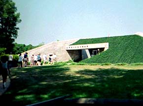
I got out our state map and realized we were far from where we should be. How far was unclear because in Richmond, the exit number sequences change unpredictably as highways merge and separate, so I could not easily tell how far the right exit was. With Frank urging me to stay calm, I got back on the interstate and eventually found the right Laburnum Avenue exit. We had to drive a way through a congested area but eventually found Battlefield Park Road. After passing a couple of other Civil War forts, I saw the sign for Fort Harrison and pulled in at 11:00, upset at being so late. Familiar cars were in the parking lot but my classmates were nowhere in sight. Well, at least they had not left without me.

I followed a path through the earthworks and caught up with the group in time to hear a cassette recording of a rebel yell. Dr. Poland said that WBT radio recorded it in 1935.

I found it online for you: Weekend America is one place to hear it, along with a brief introduction. Keep in mind that the veteran who demonstrated it was 92 at the time.

May 20, 2009

Tour: The End of the Civil War in Virginia

Sunday, May 17, 2009: Last Day of Our Last Tour
Civil War Field Trips, NVCC

Dr. Poland gave each of us a hand-drawn map showing the itinerary for our Petersburg to Appomattox tour. If you have the luxury of time, you might want to allow two days for this tour. You could easily spend most of a day at Pamplin Historical Park, with its entertaining museums and reconstructed forts. For that matter, you might want to spend an entire day exploring Appomattox.
  1. Pamplin Park, Petersburg, VA
  2. White Oak Road
  3. Five Forks
  4. Sailors Creek (3 stops, following a long drive on 460 and 617)
  5. Marshall's Crossroads
  6. High Bridge (near Farmville, VA)
  7. Appomattox, VA
sailors creek marker
See my September posts:

The Ugly Turkey Finds a Home

When we bought our house, it came furnished, mostly with items we did not particularly want. Mounted on the fireplace wall were various antlers and a stuffed wild turkey.

mounted turkeyI found the turkey ugly although it's feathers were fine-looking. It's head and neck were hideous! And I don't enjoy gazing at a dead bird.

Frank liked it more but eventually he took it and the antlers down. He mounted one set of antlers on his office wall and took the other antlers and the turkey out to the garage. The poor old bird languished there for a couple of years, although Frank offered it to a local restaurant. They did not respond.

State law prohibits selling wild animal items in most circumstances, so we couldn't just put up an ad and sell it. Well, eventually Frank decided to just haul the turkey to the dump. I protested and suggested we give it to Gail Rose at the deer farm. The farm is on Crooked Run Road just 10 minutes from here (in Basye) so we took it over there on Monday, along with a bag of plastic flower pots that I had saved and some large antlers. She was thrilled with the turkey and will put it up where visiting school children can see it.

I felt happy that the old bird has found a useful function.

May 19, 2009

Elephant Decor

This is just part of Lynn's elephant collection. And the painting on the wall is one she made of her dog Rock.

We left Flash with her over the weekend but he was terrified when Rock barked.

Things Break

We had two minor disasters yesterday. First, a failure of our phone lines. Later, a flat tire.

The phone problem was inside the house. I was on the office phone when the line went dead. I tried the other phones and found that one still worked: the one in the bedroom. Frank said that a small wire was broken and he would fix it later. Then we left to pick up Ben at the kennel.

First we stopped at the Food Lion in Mt. Jackson. When we came out, a note was affixed to the window: "Your left rear tire is flat." It was indeed -- very flat! Frank got out the jack and the (miniature) spare and started changing the tire.

The flat tire was stuck on the wheel. A young man stopped and offered to help but was also unable to loosen it. Finally a burly guy with a hammer and a strong friend removed the tire. Frank mounted the spare and drove to Hottel's Exxon.

They said the tire was not repairable. By that time all the nearby tire shops were closed for the day. We let the kennel know that we would pick up Ben a day late and came home. We were both glad that the flat happened in a parking lot and not on the highway or somewhere remote. Also, we were in a friendly town where a number of people offered to help.

Now we have a tire on order and will get it tomorrow. Frank was unable to fix the phone so we called Shentel and they sent someone who fixed it this morning. So we have phones, DSL and a fax connection again.

Now we need to take the Montero and get Ben. I have a physical therapy appointment for early afternoon so we'll do that first. It's practically next door to the kennel anyway.

May 17, 2009

Old Mill Restaurant


Last week we had lunch at the old Spangler's mill in Strasburg, VA. Near here it is said that General Custer captured much of a Confederate wagon train shortly after the Battle of Cedar Creek (October 1864).

May 16, 2009

Tumbling Run

At Fisher's Hill Battlefield, VA

May 15, 2009

Mapping Online

We are going to drive to Fort Harrison near Richmond for a field trip and I need an estimate of how long it takes. I didn't believe the first estimate of just under 3 hours (I estimated 3 and a half) so I checked other mapping sites.

I checked RandMcNally, Mapquest, Google Maps, and Yahoo maps and they all say it will take 2 hours and 50-something minutes. Interestingly, they each give different directions once we reach the Richmond area (to reach Battlefield Park Rd.) Google Maps even has us cross the Blue Ridge at a different place, recommending US-33 instead of I-64. They have a nifty feature on the main routes - you can click on a section of text in the directions and they show you a photo of the intersection with an arrow drawn on it so you can visualize the turn.men with map

Regardless of what they all say, I'm allowing 3 and a half hours. Hopefully, we'll get out early enough to allow even more time so we can take a couple of breaks without rushing. Online mapping has been way off on time estimates for us before, particularly driving down I-81 to meet Kate near North Carolina.

You know, I remember my mother pouring over maps before every trip. Instead, I am printing out directions and memorizing a rough version of the map as seen on the internet. And one of these days we'll get a GPS and let it read out the directions as we drive.

Another mapping post: Over the Mountains to Grafton

May 14, 2009

A Mother's Day Rose

Instead of a bouquet, Frank bought me a rose bush. This is a rose that I clipped from it.  The colors are lovely, aren't they?

May 13, 2009

Me With a Little Red Wagon

On Saturday we went to the annual plant sale at the Blandy Farm/State Arboretum of Virginia. We used one of their red wagons and filled it with plants.

We hadn't been to this Mother's Day Sale in several years and there were even more vendors this time - almost a hundred!

Blandy Experimental Farm is not far from Winchester.

May 12, 2009

A Note about Using My Pictures

Every now and then I get an email from someone who wants to use one of my photos. If they are with a magazine or other commercial enterprise, I propose a reasonable fee or ask what their usual rates are. And that's usually the end of it! Even businesses want to avoid paying for something.

I had three inquiries about the photo below. One was for a motel ad, one was for a local magazine, and another was from an artist who wanted to make a drawing of it as a gift for a friend. That last one I gave permission to use it for free.

Generally, I do not charge for one-time personal use of an image, although I want to hear about it ahead of time. This does not include publishing on the internet, although I might grant permission in some cases.
A View of New Market Battlefield

May 11, 2009

Drizzly Day at New Market Battlefield

Zig-zag "Worm" Fence on Battlefield


The Battle of New Market took place in rainy weather, so I felt it was appropriate to take some pictures on a wet spring day.

The annual reenactment takes place in the middle of May. See the official New Market Battlefield page.

Also see my Battle of New Market tour pages.

May 10, 2009

Our Springtime View


From our deck we see Great North Mountain. I love looking out and seeing the dogwood in bloom. (Oh, sorry, I've said that before, haven't I?)

May 9, 2009

A Picture I took of my Mom

In honor of Mother's Day, here is a picture of my mom. She was playing Frisbee with her grandchildren. And I miss her.

May 8, 2009

Horses at Orkney Springs

horse being led

horseA horse-riding group now uses the old stable and adjacent field near Lake Laura. A year ago we heard about them from Nancy Meyer, our kitchen designer (and local trail expert). We drove down to Happy Valley Road to take a look at the horses who had finished the ride on Great North Mountain. Some were resting and others were being loaded into trailers to go home.

Old Dominion Endurance Rides had planned an event this weekend but has rescheduled because of our very wet weather.