Showing posts sorted by relevance for query shenandoah river state park. Sort by date Show all posts

September 16, 2022

Our Sister Park, Shenandoah River

Our state park in Woodstock shares administrators with Shenandoah River State Park in Bentonville. The two parks are on different branches of the Shenandoah River; Seven Bends is on the North Fork and SRSP is on the South Fork.


This post shows pictures of Shenandoah River State Park. There are signs that summer is ending.

Whenever I go there, I always turn into Cullers Overlook to see the view. I also drive down to the river to see it up close. Sometimes I stop at the visitor center. On my most recent visit, I took a short trail from the campground to the river.


February 22, 2018

Fish Trap River Access, Shenandoah River

Shenandoah River State Park


This morning I had an appointment in Front Royal, and afterward I bought a salad at Martins and took it to the state park for a quiet lunch. Almost no one was there, as it was a chilly and cloudy day. I ate in the car and then walked through a picnic area down to the river.

I found steps leading to the river at the "Fish Trap River Access." I've read about the fish traps in a guide for boaters on the Shenandoah. These traps are rock dams utilized by Native Americans who built fish weirs of rocks and branches, which slowed the movement of fish so that they could be easily speared, or even scooped up into a basket.

Archaeological evidence has shown that Paleo-Indians excavated jasper and crafted arrowheads in this area over 10,000 years ago! They probably returned to the river every spring to fish.

Most fish traps were partially removed to facilitate commerce back when the Shenandoah was used as a highway for moving goods, which was seasonal because often the river is too low for even a flat boat.


Shenandoah River State Park is open year-round, even when Skyline Drive in the mountains above it is closed. There is a small entrance fee, worth paying even if all you do is look at the view from Cullers Overlook. But come down to the river too!

November 13, 2015

Front Royal's Greatest Parks

The city of Front Royal is known for its recreational opportunities. Situated between the Blue Ridge Mountains and the confluence of the two branches of the Shenandoah River, it offers scenic beauty and outdoor activities. Today I'm sharing fresh photos of the best public parks in the city and close by.


The northern entrance to Shenandoah National Park is actually within walking distance from town, but we drive up.  Skyline Drive runs the length of the park and has numerous scenic overlooks. We have a National Parks Senior Pass so we go up there fairly often.

Often we see deer or even a bear!


The second park I want to show you is Shenandoah River State Park, also known as Andy Guest State Park. It is near the small town of Limeton along Route 340. We were there on Veterans Day to walk along the river and view dusk from Cullers Overlook.


The Carson Trail runs from Front Royal Country Club to Rockland Park. It offers lovely views of the Shenandoah River.

I'm linking up to My Town Shoot Out, Skywatch Friday, Weekend Reflections, Scenic Weekends, and Orange You Glad It's Friday.

But keep reading! There's more! 


'

Eastham Park is in the city of Front Royal at the point where Luray Avenue reaches the South Fork. It has soccer fields, a paved trail, a dog park, and access to a boat ramp.

The picture of the kayaker is from last month; the rest of them are very recent.


There are other parks within the city limits, including a couple of nice playgrounds and a small park in the historic district that has a gazebo where concerts are held.

November 16, 2018

Seasons Change at Shenandoah River State Park


I stopped by Shenandoah River State Park today to eat the lunch I bought in Front Royal and take a few pictures. Much of the ice and snow we got yesterday had already melted. 

North Fork of the Shenandoah, Near Bentonville.

The view from Cullers Overlook looked much different from the way I saw it on October 29th. I'm glad I went there that day because autumn colors from that viewpoint look really special. (Are you ready for a great view?)


Sharing with Skywatch and Orange You Glad It's Friday.

Although autumn went by quickly this year, I did get to the state park and a few other places were the colors were wonderful. There were other favorites that I missed, partly because I went before the trees had donned their bright outfits.

You can see the Bentonville area from Skyline Drive.

Sharing with Weekend Reflections.

The last picture shows a white board in the state park's visitor center. 

Sharing with Signs, Signs.

March 21, 2014

Snow at Cullers Overlook

It's officially spring in Virginia but there's still a chance we'll get more snow. For now, most of it has melted except in the mountains. Here are some photos from February taken in Shenandoah River State Park.


The state parks do a good job of plowing their roads, but when we arrived the overlook parking lot had not been plowed yet. A plow arrived while we were there however.  This park is a good alternative to Shenandoah National Park when Skyline Drive is closed due to snow or ice.

As you can see, Cullers Overlook always offers a great view! I've posted pictures of it in other seasons. The Massanutten Mountains provide a dramatic background for the valley and a few of the great bends of the South Fork of the Shenandoah.


The interpretive sign is back! It was missing when we were here in November but it's been reposted with a few corrections. (The old version had a spelling error, for instance.)

Everett Cullers Overlook
 Gazing upstream to your left, the gently rolling floodplain and wooded hillsides on this side of the river are the living legacy of Mr. Everett Cullers and family. This land was a portion of the larger farm that was acquired by Everett and his wife Nettie in 1953. Along with their three sons, Merle, Thomas and Everett, Jr., the Cullers worked diligently to make improvements to the land and protect the beautiful river along its boundary. In 1994, the Commonwealth purchased 484 acres of the property from Merle Cullers, thus adding two miles of scenic river frontage to Shenandoah River State Park.

October 3, 2019

Seven Bends State Park Will Open Soon!

Our newest state park will open to the public later this month. Construction on Phase One is complete and facilities will open after they pass inspection. The official Ribbon Cutting will be later, perhaps in early spring. 


Seven Bends State Park has two vehicle entrances. (You can also enter by canoe or by hiking.)  The first photo shows the view at the Hollingsworth Road entrance. This is past Muse Vineyards near Woodstock. 

North Fork of the Shenandoah from the low-water bridge.
When the river reaches flood stage, you will not be able to reach the park except possibly by hiking. There is a swinging bridge that people use to reach Muse Vineyards when the low-water bridge is flooded.
Entrance to Stairway down to the Bridge.
The Swinging Bridge Seen from Hollingsworth Road.
Now let's go to the Lupton Road entrance. We drive down a narrow road and cross the river on another low bridge. Enter the park and we see a curved fence which once enclosed a pony ring when the property was Camp Lupton, a summer camp used by Massanutten Military Academy. The old camp buildings were demolished except for a small pony barn.
Sharing with Fences Around the World.
A small picnic shelter has been completed. There are restrooms next to it but they are waiting inspection.

Corn is still being farmed here for now.

The main recreational activities in the first phase of the park will be hiking, fishing, and canoeing. The narrow roads into the park limit vehicles to a fairly small size so there are no plans for RV camping.

I took these photos on October 1st and the weather was unseasonably hot so I did not walk around very much.

Some people were fishing in the river.


'

The park is named for seven of the turns in the Shenandoah River, probably for the seven bends that you can see from Woodstock Tower. There are many more bends in the river, both in this North Fork and also in the South Fork on the other side of the Massanutten Range. After the two forks join near Front Royal, there are even more bends before it reaches the Potomac.


January 26, 2024

Snowy Monday, Shenandoah River State Park

 Bentonville, Virginia

The snow is gone now, but I still have pictures of it to share. On Monday, I left Charlie at doggy daycare where he could hopefully get some exercise. I’ve had to to walk him on ice and snow, which is not easy. I went to Front Royal to buy a few groceries and seek photo opportunities.

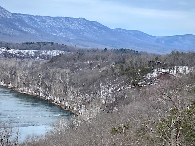
I checked the status of Skyline Drive, but it was still closed while they cleared snow. (They opened the middle section later that afternoon.) In the valley below Skyline Drive is Shenandoah River State Park, and they rarely close so I headed there. My first stop was Cullers Overlook, which has a great view.

This panoramic shot has a “fisheye” distortion, but it shows you a full bend in the river. The next view is looking downstream with the visitors center visible on the right.


A view like this inspires a selfie. I’m wearing the ear warmer that Lynn gave me for Christmas. Her friend Raylene made it.

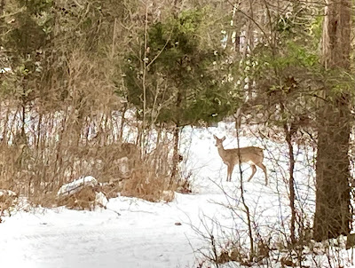
I drove down to the road by the river and kept an eye out for wildlife. A group of deer showed up, but only one was clearly visible at a time.


As I left the park, I could see the Blue Ridge Mountains to the east. At this point we are facing Shenandoah in National Park and Skyline Drive.