| When you get there, one of the first things you notice is the variety of hand-lettered signs. Next you'll probably be drawn to the inviting children's area. Once you leave that area, don't expect the plethora of signs to keep you oriented though. Some of them are just for fun! In fact, if you lack a strong sense of direction, take a compass or GPS! |
 | |
 |  |
 |  |
June 25, 2010
Welcome to Boxerwood
I heard about Boxerwood Nature Center and Woodland Garden when a local garden club member mentioned it as a great place to teach children about plants. It's in Lexington, Virginia.


June 24, 2010
A Playful Nature Center
Boxerwood Nature Center and Woodland Garden has a serious-sounding mission: "to educate and inspire people of all ages toward becoming successful and environmentally responsible stewards of the earth." However when you go there the mood is not solumn. Sort of a combined arboretum and park, Boxerwood not only has a fun play area for children but also invites adults to play by it's joking signs and general light-heartedness.


Above: Lynn checks out a "My way" sign.
Below: Even I tried out the swings.

Woodland Fences and Furniture
 One of the things that impressed me at Boxerwood in Lexington was the variety of rustic structures made from branches. Below we see Frank and then Lynn enjoying the imaginative landscape.


June 23, 2010

June 22, 2010
Finding Books
The internet is a great tool, but the richest sources for historical research are still old-fashioned books. But the internet is an excellent place to find out which books might help. I like using books.google.com and Amazon books . They behave differently so I use them both.
 If I don't find the title I want in the library, I go back to Amazon and check the price there. I like seeing if someone is selling a used copy there (shown in a box on the right side). If both the new and used copies are expensive and I don't need the book right away, I put it on my Wish List. Not only does that mean someone might buy it for me as a gift, but it also gives me a list to check later and see if the price has changed.
. They behave differently so I use them both.Google books will show you snippets from the books that answer your search query. Sometimes Google will show you several pages (when not restricted by copyright) so you can read text online, which is extremely helpful when the book is no longer available. Also, the excerpts will help you judge whether the book offers information that is unique and not just a duplicate of something you've already read.
Amazon books will list items that match your search, although some unrelated items will probably show up too unless you restrict your search very carefully. You can click on the titles and find additional details, including reviews of a book if it is recent.
will list items that match your search, although some unrelated items will probably show up too unless you restrict your search very carefully. You can click on the titles and find additional details, including reviews of a book if it is recent. Since I could easily buy more books than I can afford, I keep my local library's website bookmarked and go there (in a new browser window) to check for titles that I've identified as useful. Most libraries now have an online catalog, and from our county library system's site, I can reserve books and have them delivered to my local branch.
 If I don't find the title I want in the library, I go back to Amazon and check the price there. I like seeing if someone is selling a used copy there (shown in a box on the right side). If both the new and used copies are expensive and I don't need the book right away, I put it on my Wish List. Not only does that mean someone might buy it for me as a gift, but it also gives me a list to check later and see if the price has changed.
June 21, 2010
Garden Sign

 Frank made a charming little sign for the garden. He painted a pileated woodpecker and a hummingbird on it, since these are birds that we really enjoy watching in our yard.
Right: A columbine (aquilegia) in our garden. These flowers do well in partly-shady spots.
June 20, 2010
Interchange on WV 55
 West Virginia Route 55 between Wardensville and Moorefield is a modern divided highway. A sign identifies it as the "Robert C. Byrd Appalachian Highway System." It's part of a hundred-mile-long highway project called "Corridor H."


June 19, 2010
The Paw Paw Tunnel

 Our first field trip of the season ended at the Paw Paw Tunnel on the C&O Canal in Maryland. We walked slightly over a half-mile from the parking lot.
Completed in 1850, the tunnel provided a shortcut for the canal in a place where the Potomac River twisted and turned through the mountains.
June 18, 2010

June 17, 2010

June 16, 2010
Jesse McNeill
 Here we see a carte-de-visite photo of Jesse McNeill, who took over the leadership of McNeill's Rangers when his father was killed near Mount Jackson in 1864. I found a 3-page biography of Jesse in Faces of the Confederacy: An Album of Southern Soldiers and Their Stories
 by Ronald S. Coddington.
The portrait of Jesse stands out among the pictures in the book for it's laid-back yet insolent-looking pose. But Jesse turned out to be talented and daring, successfully capturing two Union generals in a dramatic raid in Maryland.
After the Civil War, Jesse appears to have been surprisingly modest, not commenting publicly on the raid until 1907, when he credited "the brave, heroic band of men" that he had the honor to command.
Fort Mulligan, Petersburg, WV
 Fort Mulligan is a well-preserved Civil War fort perched high on a hill. Originally built by Union forces to protect the South Branch Valley, it was later abandoned and then used by Confederates. Today it overlooks the Grant County Hospital and the town of Petersburg, with mountain views beyond. This is not very far from Moorefield but it was not included on our field trip there.
A number of interpretative signs present the fort's story. Don't miss the three-part sign on the wall between the flagpoles.

 Since I've been following the history of McNeill's Rangers, I was interested in the markers dealing with their exploits. A detailed story of the rangers is on one of the markers (see yesterday's post on Fort Mulligan). Here's a much shorter version from a section called Civil War comes to Hardy County.
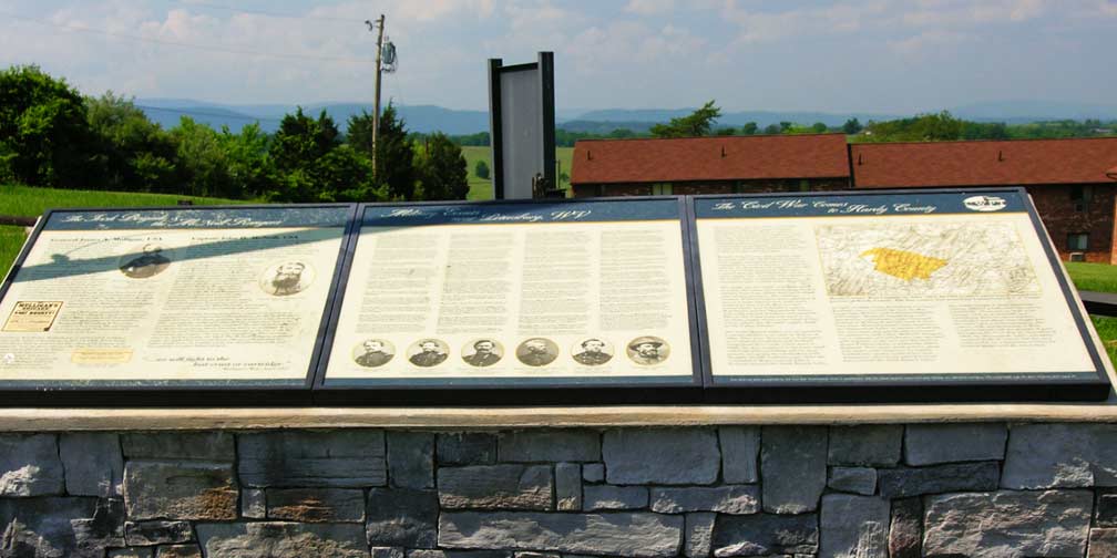
 Since I've been following the history of McNeill's Rangers, I was interested in the markers dealing with their exploits. A detailed story of the rangers is on one of the markers (see yesterday's post on Fort Mulligan). Here's a much shorter version from a section called Civil War comes to Hardy County.
"McNeill’s Rangers was a company of Confederates who operated with impunity in the area and did much to thwart Federal efforts to protect the B&O Railroad. Their many small actions, along with larger scale incursions by regular Confederate cavalry resulted in a more determined effort on the part of Federal forces to hold the South Branch Valley."Grant County, by the way, was once part of Hardy County. When it split off in 1866, it was named after U.S. Grant.
In 2008, I flew in to Petersburg Airport in a small plane with our friend Gordon. Petersburg WV is a much smaller city than Petersburg VA.
June 15, 2010
Story of McNeill's Rangers told at Fort Mulligan
 At Fort Mulligan in West Virginia you can read the story of John "Hanse" McNeill on a marker under the flag pole. It shares a panel with The Irish Brigade and Union General James A. Mulligan.

"Captain John H. McNeill, CSA John Hanson McNeill was born June 12, 1815, a short distance from Moorefield. In April of 1861, he was commissioned by Missouri Governor Jackson to raise a company of militia and join General Price. Twice commended for bravery, McNeill was wounded at Lexington and later captured, along with his son Jesse. After a daring escape from prison, McNeill and his son returned to Hardy County and once again tool up the cause of the Confederacy.
Captain McNeill’s company of 1st Virginia Partisan Rangers was accepted into Confederate service on September 24, 1862. It was merged into the 18th Virginia Cavalry, and then part of McNeill’s command was reassigned in February of 1863. The other section remained under McNeill’s personal command. Few groups were more effective that the some 210 men of the McNeill Rangers. Hardy County served as their main base of operations. The McNeill Rangers were considered “bushwhackers” by many Union generals as they pursued their objectives—creating general havoc among the Federal troops, disrupting traffic and communications on the B&O Railroad, and foraging for beef cattle to supply the Confederate armies.
On October 3, 1863, having learned of a wagon train bringing supplies to Union troops around Harrisonburg, the McNeill Rangers attacked a force of Federals guarding the bridge over the Shenandoah. They captured the bridge and some 60 Union prisoners, but in the confusion McNeill was mortally wounded. He was taken to the home of a Methodist minister where, knowing they were in danger of capture, he said “Goodbye, my boys, leave he to my fate. I can do no more for my country.” He was later smuggled to Harrisonburg where he died November 10, 1864. The McNeill Rangers continued under the leadership of his son Jesse, who never forgot what his father taught him—in leading a raid, one should always look well for a getting-out-place before going in."


June 14, 2010
McNeill's Cumberland Raid
| McNeill's Rangers, led by Jesse McNeill, pulled off a daring raid in which they captured two Union generals in Cumberland, Maryland. Our class traveled to Cumberland to see where this took place. The town has changed since 1865, of course, and the hotels where the generals were taken prisoner are no longer there. |  |
 Below we see an old historical marker that was originally mounted on the former Revere Hotel. It was torn down in 1965 and the site is now a parking lot and fast food restaurant.

Capture of Generals B.F. Kelly and George Crook
— Nights, February 21–22, 1865 —
A company of Confederates, young men from Cumberland, Maryland, Hampshire and Hardy Counties, West Virginia, captured several picket posts, obtained the countersign “Bulls Gap,” rode into the city, captured two commanding Union Generals, Kelly and Crook, and Adj. General Thayer Melvin, and sent them to Richmond, Virginia, as prisoners of war, without firing a shot.
General Crook was captured in this building, then known as “Revere House.” Generals Kelly and Melvin were taken from the “Barnum House,” (now Windsor Hotel).
General Lew Wallace was stationed here, in command of a large body of Indiana Zouaves; also Brig. General Hayes, later President of the United States.
This most daring episode of the Civil War created a great sensation all over the country, as at the time several thousand Union troops were stationed in Cumberland.
(The Kenneweg Building—formerly old
Revere House—was located on
this site. Razed in 1964.)
June 13, 2010
History Students Lost and Found
Civil War Field Trip Near Romney, WV
We stopped at an air strip along WV Route 8 near the Romney bridge. Some members of our car-caravan had gotten separated from the class in a construction zone and were temporarily lost. When they reached Romney they were able to get a cell phone signal and called for clarification of directions. Before long the group reassembled for a lecture here.

 The Civil War interpretive marker concerns Captain George W. Stump, CSA. However, our class was not there to study Captain Stump. We were learning about the surrender nearby of many members of McNeill's Rangers after Appomattox. They surrendered at "Sycamore Dale" after negotiating to keep their weapons.
June 12, 2010
Learning Tools, Civil War Tours
 Professor Poland devotes an extraordinary amount of effort to pack education into his history field trips. In addition to research, he makes many flip charts and maps, plus he and his wife traverse the entire route ahead of time in order to scout out suitable locations for stops and short hikes.
Here we see a chart listing estimates of the number of partisans or guerrillas in the American Civil War. (Click on the image to see it larger.) And then we have one of his maps, this one dealing with McNeill's Rangers and plans to attack the B&O Railroad. The illustrations depict John "Hanse" McNeill, Brig. Gen. John Daniel Imboden, Maj. Gen. Thomas Lafayette Rosser and Harry Gilmor.
The professor always cautions us that his maps are "not to scale."


June 11, 2010
McNeill's Last Charge
Just south of Mount Jackson, Virginia stands this marker. In the distance you can see the present-day bridge over the North Fork of the Shenandoah. 

McNeill's Last Charge
In the predawn darkness of 3 Oct. 1864, Capt. John Hanson McNeill led thirty of his Partisan Rangers, including local resident Joseph I. Triplett, against a hundred-man detachment of the 8th Ohio Cavalry Regiment that was guarding the Meems Bottom bridge on the Valley Turnpike. The attack ended in fifteen minutes with most of the guard captured and McNeill, among the best-known Confederate partisan commanders, mortally wounded. Taken first to the Rev. Anders R. Rude’s house a mile south, McNeill was moved on 20 Oct. to Hill’s Hotel (Stoneleigh) in Harrisonburg, where he died on 10 Nov. His body was later reinterred in Moorefield, W. Va., his home.I've been researching McNeill lately as a follow-up to a field trip in May which covered the exploits of "McNeill's Rangers" in West Virginia and Maryland. See all my McNeill posts.
June 10, 2010
Rude's Hill and Locust Grove
 In the Shenandoah Valley between Mount Jackson and New Market rises Rude's Hill, scene of several incidents during the Civil War. A pair of Civil War Trails markers has joined the older historical markers here. The marker on the left deals with Stonewall Jackson in 1862 and the marker on the right deals with actions in 1864 including an attack by McNeill's Rangers which resulted in the death of John "Hanse" McNeill. Since I've been researching McNeill in connection with a history class, I decided to revisit the markers today.
Below (in blue) are excerpts from the markers. (Click on a picture to see a larger version.)
 When I read that "Locust Grove" was still standing about 600 yards north, I decided to look for it. I'm pretty sure this is it. The addition has been rebuilt and "insulbrick" siding was installed at some point, but otherwise the architecture matches the old photograph.
| This old house photographed during the early 20th century and still standing about 600 yards north on the west side of the Valley Pike, was occupied at the beginning of the Civil War by a Lutheran minister, Rev. Anders R. Rude. Gen. Thomas J. “Stonewall” Jackson’s small Confederate force went into a defensive position here after retiring from the battle at Kernstown, March 23, 1862... By April 2, 1862, Jackson and his staff occupied the Rude home where they were quartered until April 17. All dispatches from this headquarters bore the dateline, “Rude’s Hill”—a name that has lasted until this day, even though Rev. Rude left the Valley during the fall of 1862. |  |
| On Oct. 3. 1864, the famous partisan ranger, Capt. John H. McNeill led a command of approximately 50 men in a predawn attack against a Federal detachment guarding the Shenandoah River bridge. Mortally wounded in this attack, McNeill was carried by his comrades to “Locust Grove,” formerly the Rude home, where he was cared for until removed south to Harrisonburg where he died. During his stay at Locust Grove his disguised identity was uncovered by Gen. Philip Sheridan, now the Federal commander, who reported “McNeill was mortally wounded and fell into our hands. This was fortunate, as he was the most daring and dangerous of all the bushwackers in this section of the country.” |  |
 When I read that "Locust Grove" was still standing about 600 yards north, I decided to look for it. I'm pretty sure this is it. The addition has been rebuilt and "insulbrick" siding was installed at some point, but otherwise the architecture matches the old photograph.
This is along Route 11 just north of the Shenandoah Caverns Road.

Subscribe to:
Posts (Atom)