July 31, 2011

While We Were at the Shore...

Benny and Flash stayed at the 7 Bends Kennel. One of the vets prescribed a new ear medication (Posatex) for Benny, who has long suffered intermittent infections in his right ear. It worked very well, clearing up the yeast and most of the bacteria.

Hooray for Ben C. Spaniel!

Earlier Post: Cocker Spaniel Ears (2010)

July 30, 2011

Frank, Food, Beach Towns

First we have a picture of Frank in front of Mr. Baldy's Restaurant in Chincoteague.  Next we see him with an ice cream cone. And finally, he's eating lunch in Ocean City.  I guess it looks like his ate he way up the Eastern Shore. 

But actually, he was good-natured about posing and doesn't mind being pictured online, so I take advantage and use him as a model.

July 29, 2011

Basic Geography of our Island Trip


I've been posting pictures from Assateague and Chincoteague for several days so I thought I would explain the basic geography. Both are islands, with Assateague stretching out along the Atlantic Ocean and Chincoteague nestled between it and the mainland.There's another small island between Chincoteague and the mainland, and there's also a visitor's center for the NASA's Wallops Island Flight Facility, much of which is on the mainland, although the actual Wallops Island lies south of Chincoteague Island.


I may be using the term "mainland" too loosely here. This part of land is actually a peninsula, called the Delmarva Peninsula (short for Delaware-Maryland-Virginia).  To further complicate things, the region is also called the Eastern Shore because it lies east of the Chesapeake Bay.

Anyway, you can drive out to Chincoteague and Assateague Islands thanks to causeways and bridges. Chincoteague is both an island and a town, and to complicate things, it is the name of a wildlife refuge on Assateague Island.

For our trip to the Eastern Shore, we entered at the southern tip of the peninsula via the Chesapeake Bay Bridge Tunnel. It's 20 miles long and quite an engineering feat. We drove up US 13 (for about an hour not including a stop for dinner at Wachapreague) and turned east at Wattsville to reach the islands. On our homeward journey we took a northward route, stopping at Ocean City and then driving to the upper Chesapeake Bay Bridge and from there westward toward home.

July 28, 2011

Assateague National Seashore

Assateague Island, VA


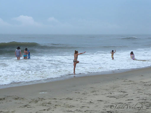
I like the beach at Assateague because it is relatively uncrowded and clean — and beautiful!

When you enter the island, you pay a National Parks fee and it covers the wildlife refuge attractions and the seashore. If you have a National Parks Pass, you don't need to pay. Frank bought the Senior Pass when we visited Yorktown in 2007 and we've been using it ever since.


July 27, 2011

History Told at Assateague Lighthouse


As we climbed the steps inside the lighthouse, I paused on the landings to look out the windows and read the paper signs. One told about the Civil War Years on Assateague and its neighbor Chincoteague Island. The lighthouse that existed at that time was shorter (45 feet tall) and dated from 1833. Here's an excerpt:
At one point rebels did manage to put the Assateague light out. The Confederates wanted to ship arms through the channel to the mainland and tried to get past Chincoteague and into the bay under disguise. A rebel schooner did reach the mainland and in response to a request for help, in 1861 U.S.S. Louisiana was sent up from Hampton Roads to intercept it.


After that a Union platoon was based at the lighthouse and another on Chincoteague. The loyalty of the islanders was recognized when free transport of seafood to the north was granted.


Throughout the war peninsula farms were an important source of food for the Union army.
(Notes by Chincoteague Natural History Association.)

Another sign tells the general history of the lighthouse and Assateague Island, beginning with it's use by Native Americans prior to European settlement in the 17th century.

Click on the image to see a large version.

Short Film from the Assateague Light

The lighthouse at Assateague is open more often then it used to be, and many visitors make the climb to see the view. Since it takes some effort to reach the observation platform, I thought I'd share a longer look at the view for those who haven't made it there. Click the start button on the video below.

In case you notice that the location seems a long way from the water, it is farther than it was originally. The island has changed over the years, with land building up in some spots and washing away in others. This is the nature of barrier islands on the Atlantic Ocean.

July 26, 2011

Climbing the Assateague Lighthouse

It had been years since I'd hiked to the light house on Assateague Island. Since Frank's sister was with us and the light house and adjacent art gallery were open, we decided to make the quarter-mile walk to the light.

Frank walked the trail with us but declined to climb the 198 steps up to the top. His sister and I made it up there while Frank stayed on the ground where mosquitos punished him without mercy.

For visitor info, see the Assateague Island site.


The last photo shows the view toward Chincoteague Island.

July 25, 2011

Sea Treasures... and Bricks


We stopped at an odd little shop in Chincoteague to look for souvenirs. The floor inside was made of bricks from far and wide. The woman running the shop said that customers bring in bricks sometimes to add to the collection. These include some from Grafton, WV.  (Yep, we've been to Grafton.)

The subject in the right-hand photo was obscured by a reflection on the glass, but I like it anyway.

July 24, 2011

Chincoteague Ponies

Chincoteague Island, VA


Chincoteague is famous for its ponies and we saw some for sale next to McDonald's on Maddox Boulevard.

The 2011 Chincoteague Pony Swim is coming up in a few days: July 27! At "slack tide," ponies from Assateague will swim across the channel to Chincoteague. After resting, they will parade to the carnival grounds. See the Pony Swim site.


You might also like these posts:

July 23, 2011

Egret, Assateague Island

This is a pretty common scene on Assateague Island. The marshes are home to many birds.

See earlier post, The Egret Flies.

July 22, 2011

Wooden Men of Chincoteague

Above: Viking Across the Road from a Shop

Below: Sea Captain at the Chincoteague Inn Restaurant

July 21, 2011

Gulls on a Rail

Chincoteague, VA


I believe these are laughing gulls. Perhaps they are laughing because someone gave them snacks!

While I'm not an advocate of feeding gulls from your deck (lest they become a nuisance), I enjoyed seeing them up close and photographing them.

We were at the Assateague Inn, where we stayed in June 2008 and also on an earlier trip to the Eastern Shore.

July 20, 2011

Return to Wachapreague


At the Island House Restaurant
We visited this restaurant on the Eastern Shore three years ago (see this post), and returned there earlier this month on our way to Chincoteague. From our table we could see Wachapreague Channel and marshland. Beyond that is a barrier island and the Atlantic Ocean.

July 19, 2011

Afternoon in Glebe Harbor


We took Frank's sister to Glebe Harbor and showed her the pretty little beach on the lower Potomac.

We also checked on the house recently vacated there by our long-time tenant.

For more views of this beach, see

July 18, 2011

The Hollingsworth Mill, Winchester

Stone Mill, Circa 1833
This mill was built on the site of an earlier grist mill from the 18th century. Now a museum, it stands near Abram's Delight and the Winchester Visitors Center on Pleasant Valley Road.

Winchester is in the northern part of the Shenandoah Valley in Virginia. It was founded in 1744 by Colonel James Wood, who was originally from Winchester, England.

The Civil War Trails marker for Abram's Delight tells us that the house is "experienced the passage of both Union and Confederate armies during the war." Read the complete text on HMDB.org.

"In the spring of 1864, Union Gen. Franz Sigel and several of his staff members occupied Abram’s Delight."
Another marker tells us more about the Hollingsworth family and the mill.

July 17, 2011

Abram's Delight

Named for Abraham Hollingsworth, early settler in Winchester, Virginia

The stone house called Abram's Delight was built by Abraham Hollingsworth's son in the mid-1700's. The Hollingsworths were not famous people, but their home has been preserved and is now open to the public.

We enjoyed visiting it and the adjacent mill which is now a museum. You can read about the family and the property on the Winchester-Frederick Historical Society website.

July 16, 2011

Log Cabin at Abram's Delight

Winchester, VA

This log cabin was moved from downtown Winchester and rebuilt at Abram's Delight. It represents the sort of cabin that Abraham Hollingsworth built around 1728.

Link: Abram's Delight on Washington's Frontier Forts Website

July 15, 2011

I Tried to Tell Him...

...you can't fix an inflatable bed with duct tape.

July 13, 2011

Badminton Ballet?


Frank and his siblings practiced badminton on our court — actually on our cul-de-sac, 7/2/2011.

July 12, 2011

We Have Fawns!

I saw them on the road when I was walking Benny: two spotted fawns with their mom. A few days later we saw them from the car.

July 10, 2011

House At Glebe Harbor: Waterfront!


Frank has reduced the monthly rent for the house at Glebe Harbor. to $995. We hope it rents soon.


July 8, 2011

On Skyline Drive

A week ago we took Frank's siblings to Shenandoah National Park. I didn't take many pictures this time. We did see a bear though! He was ambling off in the woods not far from the Drive. I was driving the car and could not get a photo of him.