August 12, 2011


August 10, 2011
Delayed Blogging
Yes, I'm behind on my blog posts. Frank's sister left three weeks ago and I'm just now finishing up posts about her visit. I tend to spend too much time fixing pictures in Photoshop: straightening, cropping, brightening, trying to get pixelated skies cleared up.
Meanwhile, I've reactivated Frank's blog and started a page on the Shenandoah Valley. I've also helped Frank keep his Postlets and Craigslist ads current.
I'm afraid my daughter's blog is even farther behind than mine. She is viewing Mount Everest while posting a travelog about her visit to Madagascar, which was two months ago. Of course, it's difficult writing on the internet whike traveling around the world.
Meanwhile, I've reactivated Frank's blog and started a page on the Shenandoah Valley. I've also helped Frank keep his Postlets and Craigslist ads current.
I'm afraid my daughter's blog is even farther behind than mine. She is viewing Mount Everest while posting a travelog about her visit to Madagascar, which was two months ago. Of course, it's difficult writing on the internet whike traveling around the world.


August 8, 2011
McCormick's Farm

On the way home from Natural Bridge, we made a brief stop in Raphine so Frank's sister could see the McCormick Farm, a scenic and historical park.
 |  |
 | Walnut Grove Where Cyrus Hall McCormick invented and in 1831 demonstrated the first successful reaper to introduce the era of farm mechanization is designated an historic landmark of agricultural engineering by American Society of Agricultural Engineers. Dedicated in 1972. |

August 7, 2011
Historical Markers Online
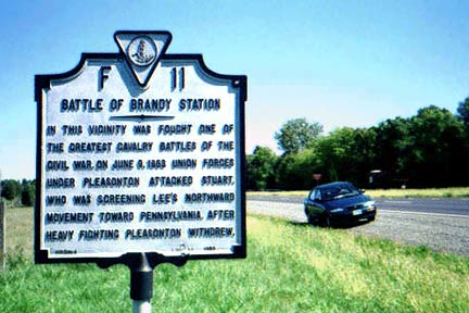
There are other sites depicting historical markers, such as Images Historical Markers and Historical Marker Society of America. Many sites are devoted to markers from a particular state, and Virginia's Department of Historic Resources has an official site.
While I happen to be a fan of historical markers, I should include a caveat. They are not always historically accurate and are not always in the right place! If you see one that seems prejudiced in favor of the Confederacy, for example, consider when it was erected and who sponsored it. For a cynical and in-depth look at this topic, read Lies Across America: What Our Historic Sites Get Wrong
 (available at Amazon).
Still, I like markers and interpretative signs and have mentioned them many times on this blog. Click on the Signs tag to see examples.
August 6, 2011
Civil War Trails: Natural Bridge

 I wasn't expecting a Civil War Trails sign in front of the visitors center at Natural Bridge, but there it was: "Natural Bridge — Time Out for Touring — Hunter's Raid."
It starts with a summary of the 1864 Campaign of Union General David Hunter's army, including the Battle of Piedmont, the burning of VMI, and his defeat at Lynchburg. Then it describes the armies visiting Natural Bridge.
On June 14, 1864, Union Gen. David Hunter’s army marched near here en route from Lexington to Lynchburg. Union Col. David Hunter Strother wrote, “We passed within three miles of the Natural Bridge. Officers were much disappointed by not being able to see it. Lieutenant Meigs and some others did go by that road.”
After Hunter’s attack on Lynchburg was repulsed June 17-18, Confederate troops passing through this area wanted to view Natural Bridge. Assistant Surgeon Thomas Fanning Wood of the 3rd North Carolina Infantry later wrote in his memoirs, “On the 23rd started on the march towards Lexington, and on the same day I got permission to visit or go by the Natural Bridge. … We had pointed out to us the letters G. Washington carved in stone, which were once quite plain, but time has nearly effaced the last vestige of them. … The story was that George Washington had climbed this ledge to the top. None of us tried this experiment, but we learned that Henry MacRae [of the regiment] … climbed to a very dangerous point, and finding he could not get to the top had to be rescued by a rope let down from above.”
- See the rest of this marker on HMDB.org.
- See my Civil War Field Trips page on the Battle of Piedmont
- Earlier Post: Battle of Lexington
August 5, 2011
Natural Bridge and Cedar Creek


 The dramatic gorge at Natural Bridge was carved out by Cedar Creek, a tributary of the James River.
A brief sign provides impressive numbers:
"215 feet high, 40 feet thick, 100 feet wide with a 90 foot span between the walls. The arch contains 450,000 cubic feet of rock weighing 72,000,000 pounds or 36,000 tons and is estimated to be at least 500 million years old. At it's peak, the bridge is 1,160 feet above sea level."
It goes on to say that Route 11 passes over the bridge and closes with a quote from Thomas Jefferson:
"The most sublime of Nature's works."


August 4, 2011
Monacan Village at Natural Bridge
Monacan Indian Exhibit
 |  |

 Natural Bridge has a number of tourist attractions. One of the most authentic features is the Monacan Village, modeled after Native American settlements of the region.
 You can click on the sign to see a large version. Here's how it starts:
Monacan Village
Circa 1700
The Monacan Indian Nation and Natural Bridge invite you to witness, in a living history environment, glimpses of what life would have been like in a small Monacan Village 300 years ago along the banks of Cedar Creek.
This is a project of reconstructive archaeology. (Reconstructing a Monacan village according to archaeological record of the southwestern and Piedmont regions of Virginia.)
The Monacan Indians are a Siouan speaking people, who migrated to this region over 1500 years ago from the northwest.


You might also like Powhatan's Kitchen.

August 3, 2011
Here We Are at Natural Bridge

 Frank's sister took the picture of us at Natural Bridge.
 Neither she nor Frank had been there before and they were both impressed by it. I'd been there a couple of times and had wanted Frank to see it, so his sister's visit provided a good excuse to go sightseeing there.
Natural Bridge has been privately owned since colonial times, when Thomas Jefferson purchased it from King George III. Originally it was surveyed by a young George Washington.
Link: Natural Bridge, VA
Bear Hug

You might also like Frank at Fort Nisqually.
August 2, 2011
Lunch in Buchanan

 On the day we went to Natural Bridge we wanted to take Frank's sister to the Pink Cadillac for lunch but it was closed . I continued driving south and wound up in the small town of Buchanan, Virginia.
 We saw an old-fashioned drug store that boasted a grill and soda fountain so we went there for lunch. The soda fountain reminded me of the one I went to as a teenager. The shiny red and chrome bar stools looked so familiar, I expected to see Gertie standing behind the counter in her starched white uniform. My mind was time-traveling.
Link: Ransone's Soda Fountain
August 1, 2011
Queen Anne's Lace in Waterlick

 I spotted these wildflowers growing at Shenandoah River Lakes. Just now I checked past blog entries and saw that I posted pictures of Queen Anne's Lace last July AND the previous June.
July 31, 2011
While We Were at the Shore...

Hooray for Ben C. Spaniel!
Earlier Post: Cocker Spaniel Ears (2010)
July 30, 2011
Frank, Food, Beach Towns
 First we have a picture of Frank in front of Mr. Baldy's Restaurant in Chincoteague. Next we see him with an ice cream cone. And finally, he's eating lunch in Ocean City. I guess it looks like his ate he way up the Eastern Shore.
 But actually, he was good-natured about posing and doesn't mind being pictured online, so I take advantage and use him as a model.


July 29, 2011
Basic Geography of our Island Trip

 I've been posting pictures from Assateague and Chincoteague for several days so I thought I would explain the basic geography. Both are islands, with Assateague stretching out along the Atlantic Ocean and Chincoteague nestled between it and the mainland.There's another small island between Chincoteague and the mainland, and there's also a visitor's center for the NASA's Wallops Island Flight Facility, much of which is on the mainland, although the actual Wallops Island lies south of Chincoteague Island.
For our trip to the Eastern Shore, we entered at the southern tip of the peninsula via the Chesapeake Bay Bridge Tunnel. It's 20 miles long and quite an engineering feat. We drove up US 13 (for about an hour not including a stop for dinner at Wachapreague) and turned east at Wattsville to reach the islands. On our homeward journey we took a northward route, stopping at Ocean City and then driving to the upper Chesapeake Bay Bridge and from there westward toward home.
July 28, 2011
Assateague National Seashore
Assateague Island, VA
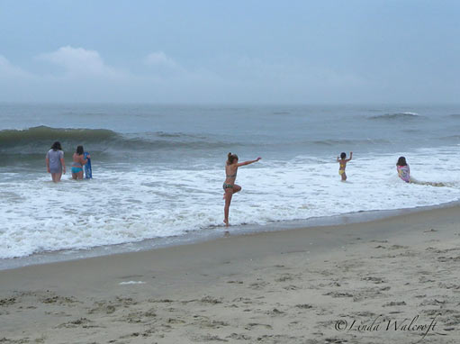

 I like the beach at Assateague because it is relatively uncrowded and clean — and beautiful!
When you enter the island, you pay a National Parks fee and it covers the wildlife refuge attractions and the seashore. If you have a National Parks Pass, you don't need to pay. Frank bought the Senior Pass when we visited Yorktown in 2007 and we've been using it ever since.
July 27, 2011
History Told at Assateague Lighthouse

As we climbed the steps inside the lighthouse, I paused on the landings to look out the windows and read the paper signs. One told about the Civil War Years on Assateague and its neighbor Chincoteague Island. The lighthouse that existed at that time was shorter (45 feet tall) and dated from 1833. Here's an excerpt:
At one point rebels did manage to put the Assateague light out. The Confederates wanted to ship arms through the channel to the mainland and tried to get past Chincoteague and into the bay under disguise. A rebel schooner did reach the mainland and in response to a request for help, in 1861 U.S.S. Louisiana was sent up from Hampton Roads to intercept it.
After that a Union platoon was based at the lighthouse and another on Chincoteague. The loyalty of the islanders was recognized when free transport of seafood to the north was granted.
Throughout the war peninsula farms were an important source of food for the Union army.
(Notes by Chincoteague Natural History Association.)
 Another sign tells the general history of the lighthouse and Assateague Island, beginning with it's use by Native Americans prior to European settlement in the 17th century.
Click on the image to see a large version.
Short Film from the Assateague Light
 The lighthouse at Assateague is open more often then it used to be, and many visitors make the climb to see the view. Since it takes some effort to reach the observation platform, I thought I'd share a longer look at the view for those who haven't made it there. Click the start button on the video below.
In case you notice that the location seems a long way from the water, it is farther than it was originally. The island has changed over the years, with land building up in some spots and washing away in others. This is the nature of barrier islands on the Atlantic Ocean.
July 26, 2011
Climbing the Assateague Lighthouse

Frank walked the trail with us but declined to climb the 198 steps up to the top. His sister and I made it up there while Frank stayed on the ground where mosquitos punished him without mercy.
For visitor info, see the Assateague Island site.


The last photo shows the view toward Chincoteague Island.
July 25, 2011
Sea Treasures... and Bricks


The subject in the right-hand photo was obscured by a reflection on the glass, but I like it anyway.
Subscribe to:
Posts (Atom)